Section 1: About the Straight Shot, aka “Non-Preferred Alternative”
What’s the City of Aspen proposing for the Entrance to Aspen?
City staff has dusted off a 25-year-old plan to reroute Highway 82 across the Marolt Open Space to directly connect with Main Street. In the Colorado Department of Transportation’s lingo it’s called the “Preferred Alternative.” They insist the only real solution for replacing the Castle Creek Bridge is a 5-lane freeway through the Marolt and Thomas Open Space at the entrance to town.
Does the City or CDOT have the right to build a freeway across community Open Space?
Not as proposed. They need voter approval for two additional bus lanes, which has not been granted.
What exactly is the “Preferred Alternative”?
CDOT’s “Preferred Alternative” is a 1998 plan to realign Highway 82 with a 4-lane freeway and a rail corridor (the fifth lane) from the Aspen Roundabout across the Marolt and Thomas Open Space. It was developed by local and state officials following a 1996 vote when Aspen voters approved a two-lane straight shot with light rail across the Marolt Open Space.
The 1996 ballot question specifically required:
- Two lanes for cars and trucks and a light rail system to the airport.
- A second vote on full design and funding plans before the open space could be used.
- A design that includes a 400-foot cut and cover tunnel so some of the open space could be recovered.
- Conversion of the existing road between the current location of the roundabout and Cemetery Lane to open space.
The 1998 “Preferred Alternative” added 2 bus lanes as a temporary measure until light rail was developed. However, the temporary bus lanes now appear to be permanent because the light rail promised in the 1996 vote has not been seriously considered since the late-1990s, when voters rejected funding for the light rail. City staff admit the rail plan is considered “dead”.
The “Preferred Alternative” is an attempt to develop a 4-lane highway and rail corridor that voters have never approved.
Is the “Preferred Alternative” the same thing as the “Straight Shot”?
Yes. Over the years, versions of this plan have been popularly called the “Straight Shot” and more bureaucratically the “Modified Direct”, because the new Highway 82 would bypass the S-curves at the Entrance to Aspen.
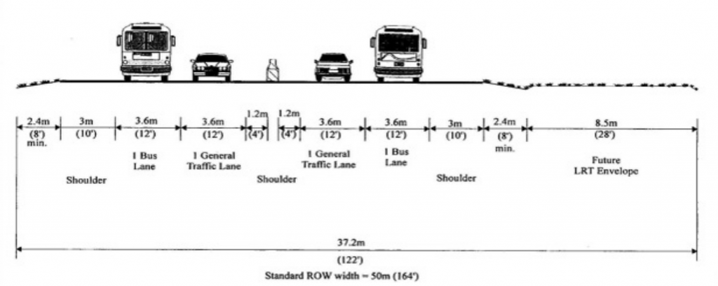
Why 5 lanes?
There are 2 car lanes, 2 bus lanes and one 28-foot corridor (the fifth lane) for possible future light rail. That requires a 122-foot wide paved freeway across the entire length of the Marolt Open Space.
Have Aspenties voted on the Prefered Alternative?
Yes, and both times it was rejected. In 1999 and 2001, the City asked voters for permission to build the Preferred Alternative: 2 traffic lanes, 2 bus lanes and a light rail corridor across the Marolt Open Space.
- In 1999, voters rejected the Preferred Alternative and light rail funding by a 53-47 percent
- Win 2001, voters rejected it by a 54-46 percent
Despite those votes, this is exactly the plan that the City wants to use today – two traffic lanes, two bus lanes and a fifth “lane” for light rail.
What about the 400-foot cut and cover tunnel, does it stay?
No. The City has abandoned its commitment to build the full length cut and cover tunnel envisioned by voters in 1996 and required in the official CDOT Record of Decision in 1998. The City is now proposing a curved, mound-like “land bridge” overpass that is shorter in length and does not preserve the topography. Such a change would require opening the official Record of Decision for reconsideration.
The cut and cover tunnel is an important part of the original plan. The length of “at least 400’…” slows traffic, and the cut and cover technique maintains the flat topography of the Marolt Open Space, allowing the popular open space and recreation area to be partially restored.
But if CDOT has approved the Preferred Alternative, isn’t it a done deal?
No. Both the 1996 vote that approved two lanes with light rail and the Aspen City Charter require another vote to approve any bus lanes as a part of the Straight Shot across Marolt Open Space. City Council is considering whether and when to put its “Preferred Alternative” on the ballot in 2023 or 2024, as an “up or down vote” with no other options considered.
What would happen to the existing Castle Creek Bridge if the Straight Shot is built?
If the Straight Shot is built, the existing bridge would become a city street that must be maintained and rebuilt at the City’s cost—before 2036, according to City Staff. City officials have given no estimates for what it would cost to rebuild the old bridge using local tax dollars.
Section 2: How the Straight Shot will change life in Aspen…in and out of the car
Won’t the Straight Shot across the Marolt Open Space make it easier to get in and out of town?
No. In fact, the afternoon rush hour traffic will get worse on Main Street and the West End. Three reasons:
- No new lanes for cars and trucks.
- Only two lanes (one in each direction) will be open to cars and trucks, So the City concedes that traffic flows will not improve.
- Two lanes will be for buses only, just like the bus-only lanes between Buttermilk and the roundabout.
- The fifth “lane” is a 28-foot wide section for a future light rail system, as it was approved by voters in So that will never be available for traffic.
- A new stop light at 7th & Main, requiring traffic to stop on the new bridge and on Main Street.
- A pedestrian crossing and possibly bus stops at the new intersection will further slow traffic.
- The “stacking capacity” from 7th Street to Cemetery Lane is transferred to new light at 7th & Main Street. That means all the cars waiting along 7th and Hallam to get through the Cemetery Lane intersection will instead stack up on Main Street, possibly past the Jerome, to get through the light at 7th & Main.
- Traffic still has to merge, so the bottlenecks will remain:
- Afternoon rush hour traffic on Main Street will still need to merge from two lanes to one lane at 5th & Main, just like it does now.
- Morning rush hour traffic will still jam up at Buttermilk, where traffic is forced to merge into one lane.
How will the West End be affected by the Straight Shot?
Nothing will change. City staff have said that the Straight Shot will not provide congestion relief in either direction. During the afternoon rush hour, traffic will still need to merge to one lane at 5th and Main, and West End residential streets will continue to be inundated with commuters and locals trying to avoid the traffic jam.
How will Cemetery Lane be affected by the Straight Shot?
Residents of Cemetery Lane and people traveling from McLain Flats Road will turn left onto the old Highway 82, and cannot turn right to go downvalley. To get into town or to travel downvalley to the schools, ARC, hospital, Aspen Highlands, airport and AABC, they’ll have to cross the current Castle Creek bridge and go through the new stoplight at 7th & Main where the Straight Shot comes into town. Once the light turns green, they can go into town or back toward the roundabout via the Straight Shot.
Will the current stretch of Highway 82 between the roundabout and Cemetery Lane become open space? No. The 1996 vote required it to become open space as a part of the compensation for crossing Marolt with two lanes and a light rail. But the City is now planning for the road between Cemetery Lane and the roundabout to be maintained but closed to general traffic. It will be available for use by emergency vehicles in the event the Straight Shot is blocked.
What are the community assets and values impacted by the Straight Shot?
Open Space: The Marolt/Thomas Open Space is one of the largest intact, undeveloped parcels of land in town. The City touts this as the “jewel” of Aspen Open space. It is widely used by the community on bicycles and on foot. Its bike paths provide vital connections between town and the schools, the ARC and the Maroon Bells. It is a highly popular spot for dogs, with room to fetch and run. Hang gliders use it to land during the summer. There is cross-country skiing in the winter. There are approximately 70 community garden plots on the open space. Birds, foxes and other wildlife use the open space as a refuge. All of these are threatened by a 122-foot-wide highway and rail corridor.
Historic: The Marolt/ThomasOpen Space is home to the historic Holden-Marolt Mining & Ranching Museum and the Zupancis Ranching Homestead, both of which are located within spitting distance of any highway alignment that connects to Main Street. It is not known whether these buildings will need to be relocated. The Straight Shot would also require removal of the historic landmarked Berger Cabin. Built in 1947, the Berger Cabin was the first local home designed by Aspen’s foremost modern architect, Fritz Benedict, using many of the features he learned during his apprenticeship with Frank Lloyd Wright.
Where will the 5-lanes go?
CDOT has so far declined to disclose the exact location of the realignment or place stakes marking where the road would go. It appears that the 122-foot wide freeway and rail corridor would have to pass just north of the Community Garden, and adjacent to the Holden Marolt Mining & Ranching Museum and Zupancis Homestead. The highway would cross Castle Creek through the Berger Cabin property and directly next to the free market and affordable housing on the quiet section of Main Street between 7th & 8th. The piers for the new bridge would be situated along the Castle Creek river bed which is an important wildlife corridor.
How urgent is the situation with the old Castle Creek Bridge?
City staff argue that there isn’t time to consider other options because Castle Creek Bridge is nearing the end of its projected useful life in 2036 ,and have said we need an up or down vote on the 5-lane Straight Shot immediately. State inspectors rate the bridge as being in fair condition with a rating of 50 (out of 100). Over $5 million in repairs to Castle Creek Bridge were completed 2022.
What are our other options?
The community has not seriously considered various options for the Entrance to Aspen since the mid-1990s. The City could reopen the conversation in 2023 to consider other alternatives. We should certainly explore ways to replace the existing Castle Creek Bridge with a safer and more useful structure that can accommodate three lanes.
Other suggestions include a pedestrian underpass at the well-used 8th Street bus stop, a roundabout at Cemetery Lane, and a straighter bridge across Castle Creek where Smuggler turns down the hill and becomes Power Point Road, creating an effective detour while the existing Castle Creek Bride is rebuilt, that moves traffic out of the West End more efficiently.
What is the proposed timing?
The City has stated that if everything goes perfectly it would take about 8-10 years to build a new bridge. But the proposal is not even on the State list of approved projects. Given the age of the Record of Decision and the Environmental Impact Statement, reopening may be required and this would add years to the process. The possibility of legal challenge exists, including resuming the 2004 litigation now on hold. The City’s estimate of 8-10 years appears to be wildly optimistic. Costs are totally unknown and could doom the project, especially since it does nothing to alleviate traffic congestion, which is a stated priority for both federal and state funds.
Contact us: info@friendsofcastlecreek.org